
Reportedly on Babia Góra there’s wind 364 days a year. It is 1725 m high and is the highest mountain of Western Beskids. “Babia Góra” can be translated as “old woman’s mountain”, but it is also often called “Diablak”, which comes from a word “diabeł” – devil.
I was there with my friends in the middle of March. In villages around Babia Góra there wasn’t any snow already but Babia Góra looked till like in winter.
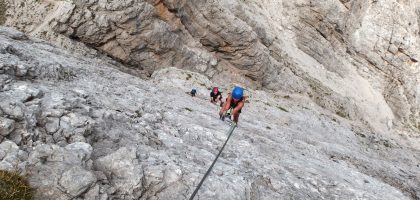
You can get to Babia Góra from north, south, east or west. Yellow trail from north called “Akademicka Perć” is the most difficult. It is secured by chains and closed for winter. We were walking from Zawoja village, by green and then red trail from west. See map of trails on mapa-turystyczna.pl.

Trees in forest confirmed that it can be very windy here. They looked like it was snowing horizontally. We were wondered if we have a chance to hike in this one day a year when there’s no wind. The weather was good, about -5℃, little clouds and sun. Close to peak we saw people who were coming back from the peak. They had caps, hoods, jackets buttoned to neck, some of them goggles and were looking like it was -20℃. We were wondered why they are so warmly dressed. For me it was so warm, that I was walking without jacket… We understood it when we came to the peak. It was so windy that it really felt like -20℃.
We didn’t spend much time on the peak. We made some photos, short rest and went further, by red trail to Przełęcz Krowiarki and back to Zawoja.
It wasn’t long route. Because of snow we were prepaired for more difficult trip. We also took crampons because we read before that it can be slippy on trail. In fact, crampons were really helpfull, but it wouldn’t be much problem to walk without them.
Close to Babia Góra Peak there is Markowe Szczawiny shelter where you can sleep or eat lunch. It is good place to eat but there is no need to sleep there if you plan to go to Babia Góra. We were sleeping in Zawoja (exactly Zawoja-Policzne) and whole trip from there was about 23 km and it took us about 8 hours with no rush.
Of course you should remember that in winter weather is not always as good as we have. Zawoja is about 600 m high so 1000 m higher it can be much colder. Sometimes, when there are clouds and snow-flurry, it can be easy to lost on trail to Babia Góra.
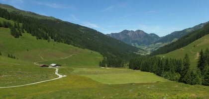
Second day of our weekend in Zawoja we walked shorter trip. We wanted to return to Warsaw on the evening so we didn’t have much time. On the morning we took a bus from Zawoja-Policzne to Zawoja centrum. Then we walked by green trail to Cyl Hali Śmietanowej, called also Kiczorka (you can see our trip on mapa-turystyczna.pl). I was a little disappointed by this trip, because on my map there are marked two viewpoints on these trails. Actually, there was any. Only forest, so there wasn’t nice views and I didn’t make even one photo this day. On Kiczorka Peak we met mountain guide. He was talking to his group of tourists that few years ago, indeed, it was nice view here, but now you can see only trees. So we were a bit late ;)


![]()
 Thank you :)


Leave a Reply